Estate Maps, 1750s-1900s

| Name: | Braid, Thomas |
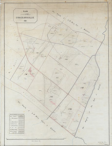
| Title: | Plan of the Lands of Cragganvallie, 1881 |
| Imprint: | 1881 |
| Pagination: | 1 map; 86 x 64 cm. |
| Shelfmark: | Lovat347 |
| Notes: | 1:2501. (30 chains = 9.5" ). Division of lots at Cragganville, near Belladrum Handwritten on map: Lovat Estate Office Beauly 8th August 1881 Thos Braid, Surveyor. Courtesy of Lovat Highland Estates and the North of Scotland Archaeological Society. View Lovat Highland Estates mapping |
| Zoom Into Map: | Click on the map to view in greater detail. |