Estate Maps, 1750s-1900s

| Name: | Henderson, Peter? |
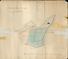
| Title: | Plan of Arable Ground and Site of Chapel at Beoraid, North Morar |
| Imprint: | 1889 |
| Pagination: | 1 map: col.; 49 x 56 cm. |
| Shelfmark: | Lovat333 |
| Notes: | 1:584. (10 chains = 5" ). Shows shaded areas for development at Beoraid. Surveyor's signature hard to read, but is based at "Lovat Estate Office". Handwriten on map: The Site of the Chapel (the contents of which are marked in pencil) was not surveyed by the undersigned and the areas are only approximate.. Courtesy of Lovat Highland Estates and the North of Scotland Archaeological Society. View Lovat Highland Estates mapping |
| Zoom Into Map: | Click on the map to view in greater detail. |