Estate Maps, 1750s-1900s

| Name: | Boulton, John, 1830-1874 |
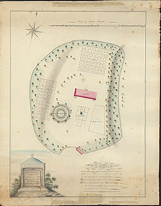
| Title: | Plan of the Churchyard of Kiltarlity |
| Imprint: | 1825 |
| Pagination: | 1 manuscript map: col.; 55 x 43 cm. |
| Shelfmark: | Lovat239 |
| Notes: | A detailed plan showing the boundaries of the churchyard, and the numbering of plots and trees. Scale 1:317. (3 chains = 7.5" ). Courtesy of Lovat Highland Estates and the North of Scotland Archaeological Society. View Lovat Highland Estates mapping |
| Zoom Into Map: | Click on the map to view in greater detail. |