Estate Maps, 1750s-1900s

| Name: | Gordon, David, 1820-1893 |
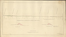
| Title: | [Sections of Embankment on Wester and mid-Crochiels, 1861] |
| Imprint: | 1861 |
| Pagination: | 1 map: col.; 40 x 70 cm. |
| Shelfmark: | Lovat191 |
| Notes: | A sketch plan of proposed embankment of River Beauly in Strathglass Scale 1:4224. (20' = 3.75" ). Courtesy of Lovat Highland Estates and the North of Scotland Archaeological Society. View Lovat Highland Estates mapping |
| Zoom Into Map: | Click on the map to view in greater detail. |