Estate Maps, 1750s-1900s
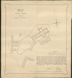

| Title: | Plan of the Ruins of Beauly Priory and of the Adjoining Burying Ground, 1848. |
| Imprint: | 1848 |
| Pagination: | 1 map; 54 x 49 cm. |
| Shelfmark: | Lovat123 |
| Notes: | Map used in agreement between HM Government and Lord Lovat 1849. Details of this agreement wrriten bottom R of map. Scale 1:3960. (3 chains = 6" ). Courtesy of Lovat Highland Estates and the North of Scotland Archaeological Society. View Lovat Highland Estates mapping |
| Zoom Into Map: | Click on the map to view in greater detail. |