Estate Maps, 1750s-1900s
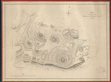

| Title: | [Mid and Wester Aigas Hill Ground, 1863] |
| Imprint: | 1863 |
| Pagination: | 1 manuscript map; 55 x 73 cm. |
| Shelfmark: | Lovat103 |
| Notes: | Handwritten in pencil at top: The pencil line shows the March of the hll grazing approximately as arranged by Lord Lovat & Mr Gavioch with all the tenantry, on 16th August 1887 Scale 1:7920. (50 chains = 5" ). Courtesy of Lovat Highland Estates and the North of Scotland Archaeological Society. View Lovat Highland Estates mapping |
| Zoom Into Map: | Click on the map to view in greater detail. |