Estate Maps, 1750s-1900s

| Name: | McLean & Morrison Surveyors, Inverness McLean, Neil (1824-47) Morrison, Hector (fl. 1830-1869) |
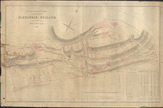
| Title: | The Plan of the Lands of Riesaurie and Ruilick and Dunmore. |
| Imprint: | 1839 |
| Pagination: | 1 manuscript map: col.; 83 x 129 cm. |
| Shelfmark: | lovat034 |
| Notes: | Map used in a 1869 disposition. Handwritten on back: Inverness 25 October 1869 Referred to in deposition of John Peter IC Cameron & Lord Lovat (then two undecipherable signatures) Scale 1:2307. (10 chains = 3" ). Courtesy of Lovat Highland Estates and the North of Scotland Archaeological Society. View Lovat Highland Estates mapping |
| Zoom Into Map: | Click on the map to view in greater detail. |