Estate Maps, 1750s-1900s
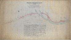

| Title: | Invergarry and Fort Augustus Railway Act, 1896 |
| Imprint: | 1896 |
| Pagination: | 1 map: col.; 71 x 132 cm. |
| Shelfmark: | Lovat013 |
| Notes: | A map of the Fort Augustus area, in preparation for the building of the Invergarry and Fort Augustus Railway Scale 1:2571. (1500' = 7" ). Courtesy of Lovat Highland Estates and the North of Scotland Archaeological Society. View Lovat Highland Estates mapping. |
| Zoom Into Map: | Click on the map to view in greater detail. |