Estate Maps, 1750s-1900s
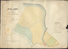

| Title: | Plan of Lands Farmed by the Abbey at Fort Augustus |
| Imprint: | 1880s |
| Pagination: | 1 map: col.; 56 x 78 cm. |
| Shelfmark: | Lovat010 |
| Notes: | An unsigned, undated, coloured, sketch of fields south of Fort Augustus Scale 1:792. (1 chain = 1" ). Courtesy of Lovat Highland Estates and the North of Scotland Archaeological Society. View Lovat Highland Estates mapping. |
| Zoom Into Map: | Click on the map to view in greater detail. |