Plans of Dunskey Estate, 1804
A volume of 20 estate plans relating to Dunskey Estate, situated in Portpatrick parish in Wigtownshire, to the south-east of Portpatrick. The maps were all surveyed in May 1804 by William Dunbar (1767-1815). Not all the original plans are present, and not all have numbers, but these are listed in the order they are in the volume below. The volume is in the possession of Dumfries and Galloway Archives.
We are very grateful to the Dumfries Archival Mapping Project for scanning these maps.
Volume contents - Plans of Dunskey Estate, 1804
- Plan of the East End of South Port of Spittal and Meoul - Plan 2
- Plan of the West End of South Port of Spittal - Plan 3
- Plan of the East End of North Port of Spittal - No.4
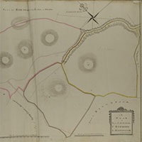
- A Plan of the West End of North Port of Spittal, Morach and Mill Lands - No.5
- A Plan of Awhirk, Birmore, Barnchilloch - Plan 6
- A Plan of Craigoch Park, Laginmore, Big Meadow and Craigoch - Plan 7
- Plan of High and Low Penminnoch - Plan 8
- Plan of Dunskey and Part of Dunoin - Plan 10
- Plan of Part of Dinvin Moor and of North Craigbovie - Plan 11
- A Plan of Enoch North and South of the Road - Plan 12
- A Plan of Craigenlee - Plan 13
- A Plan of Auchenree - Plan 14
- A Plan of Ouchtree McKean - No.15 (in pencil)
- A Plan of Killantringan - Plan 16
- A Plan of Craigslave, Moorcroft, and Craigslave Croft -
- A Plan of High Tibbert, Challoch Hill and Laigh Tibbert - Plan 18
- Plan of S. Knockglass and N. Knockglass - Plan 19
- A Plan of Crailoch - Plan 20