Estate Maps, 1750s-1960s
| Name: | Gordon, David (1820-1893) |
| Title: | Plan of the Barony of Strathfarrar reduced from the Survey of P May, 1758 |
| Imprint: | 1852 |
| Pagination: | 1 manuscript map: col.; 66 x 95 cm. |
| Shelfmark: | Lovat224 |
| Notes: | Scale: 1:36,205 (400 chains = 8.75") Courtesy of Lovat Highland Estates and the North of Scotland Archaeological Society. |
| Zoom Into Map: | Click on the maps below to order images or view in greater detail. |
Map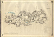
|
Reverse side
|
