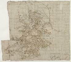
| Notes: | This map shows a portion of Strathmore. It is bounded in the east by the River South Esk (upper right), and also on this eastern margin is the town of Forfar (lower right). In the west the boundary of mapped ground is formed mainly by the course of the River Isla, although some land west of this river is mapped between Alyth and Craigisla. The Sidlaw Hills bound the area in the south and the Grampian Mountains in the north. - At the bottom right of this sheet is a fragment of another map, indicating that this sheet was once somewhat larger and has been cut down. The title Part of Anguse is in the hand of Sir Robert Sibbald.
- There is evidence of some over-writing in the hand of Robert Gordon. It was probably Gordon who added the scale bar (bottom right) also.
- The hand-drawn grid lines on this sheet can be dated to the time that Pont drew the map. The evidence for this is that the grid does not continue onto the two patches of paper that Pont has added to extend and modify the south west corner of this map and then drawn over. See Stone (1989) for a discussion of these patches.
- The exact location of the Loch of Lintrathen (top left) seems to have caused Pont some problems. On Pont 28(1) he drew it on the east side of the Melgam Water, whereas on this map he has located it on the west side.
- Three other Pont manuscripts overlap with this map: Pont 26 in the south, and Pont 27 and 28 in the west.
- Gordon's manuscript sheets 2, 4, 6, 25, 41, 42, and 43 include at least part of this area.
- See also Blaeu's printed map of Braid-Allaban (1654) for coverage of this area.
View the Pont Maps website. View maps by Blaeu and Robert and James Gordon. |