Maps of Scotland
| Name: | Pont, Timothy, 1560?-1614? |
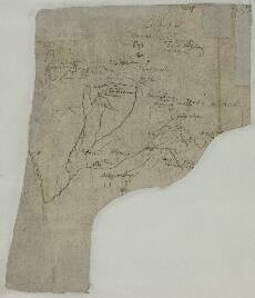
| Title: | [Upper Perthshire] - Pont 25 (back) |
| Imprint: | [ca. 1583-96] |
| Pagination: | 1 manuscript map ; 18 x 20 cm. |
| Shelfmark: | Adv.MS.70.2.9 (Pont 25v) |
| Notes: | Pont 25 contains two maps, one of which (Lower Strath Tay from Dunkeld to Benchil) is on the front side. The sheet was originally part of Pont 23.This very small scale map on the back of Pont 25 shows a large area of upper Perthshire and an adjacent part of Inverness-shire, central Scotland. The map shows Lochaber and Loch Treig to the west, Badenoch in the north, the River Tay in the east, and Loch Rannoch in the south.
View the Pont Maps website. View maps by Blaeu and Robert and James Gordon. |
| Zoom Into Map: | Click on the map to view in greater detail. |