Maps of Scotland
| Name: | Pont, Timothy, 1560?-1614? |
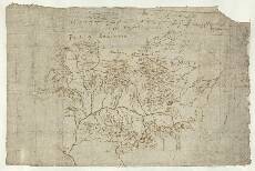
| Title: | [Glen Tilt] - Pont 20 |
| Imprint: | [ca. 1583-96] |
| Pagination: | 1 manuscript map ; 31 x 20 cm. |
| Shelfmark: | Adv.MS.70.2.9 (Pont 20) |
| Notes: | This map covers a large area northeast of modern Blair Atholl, northwest of Pitlochry. The western margin of the map runs from Blair (Blair Castle) on the River Garry in the south (bottom left) almost as far as Glenfeshie Forest and the River Feshie in the north. The most northeasterly point is the junction of the River Dee and the Clunie Water at Braemar (right margin). The whole of the drainage basin of the River Tilt in the west of the area is included, as are the basins of the Tarf River (Tarf Water) in the west, and of the Gheldy R.[iver] (Geldie Burn) in the north.
This pag[e] [com]pryseth all the Branches & River of followed by Be Mr Ti. Pont in the hand of Robert Gordon. Aalach is the yrish na[me] of atholl and the head of
View the Pont Maps website. View maps by Blaeu and Robert and James Gordon. |
| Zoom Into Map: | Click on the map to view in greater detail. |