County maps, 1580s-1950s
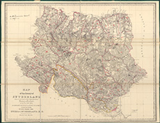
| Title: | Printed map of the County of Sutherland made on the basis of the Trigonometrical Survey of Scotland by Burnett and Scott (reduced version), 1833. With annotations. |
| Imprint: | 1833 |
| Pagination: | 1 map : col.; 67 x 86 cm |
| Shelfmark: | Dep.313/3606/1 |
| Notes: | We are very grateful to Sutherland Estates for permission to display this map on our website. Sutherland Estate mapping home page. |
| Zoom Into Map: | Click on the map to view in greater detail. |