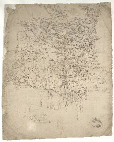
| Notes: | This particularly informative map shows the lower valley of the River Dee, Scotland's fifth longest river. It extends from a point just west of Kincardine O'Neil to the North Sea at Aberdeen (although Aberdeen itself is not drawn on the map). The map extends southward to include the Cowie Water and Carron Water at Stonehaven. To the north the map includes Skene and extends almost as far north west as Alford. - Perhaps the most curious feature of this map is the absence of Aberdeen itself. However, several of its hinterland fermtouns, such as Hasilhead, Rubslaw, and Ferryhill, which are now embraced within the modern city, are shown.
- There is a note in a hand other than Pont's that reads: tak abirdene to be heir (i.e. take Aberdeen to be here).
- Stone (1989) describes this map as 'one of the most informative of the Pont manuscripts' because of the large number of place names which it contains - 389 in total.
- Pont shows standing stones by his usual symbols at Achorthies (Aquhorthies) (lower centre right). The faint note here reads:
heir great sta[n]d:ing stones In fact, there are two surviving stone circles at this site, both with impressive standing stones. - The causeway marked by Pont with two parallel lines running from Aquhorthies north to almost Broadgriens (Broadgreens) was an important trackway. It was built up with stones to provide a way across the surrounding marshy land. We know that it was built at least as early as the fourteenth century, and may have originated much earlier.
- The relative distances shown by Pont were later criticised by Robert Gordon, most notably in his mapping of the coast between Stonehaven and Aberdeen. These errors caused Robert Gordon to write several notes off the coast:
The part of the coast
besyde Aberdein is all amisse
and: Item the Mylis are too little also: Muchalls in the mearnis is too farr distant from Abirdeen - Drum Castle (north of the Dee, near Peterculter) is one of the earliest Scottish tower-houses. The massive tower was built soon after Robert I's grant in 1323 to William Irvine, whose descendant extended it in 1619.
- No other Pont map includes this area.
- Several of Robert Gordon's manuscript maps cover this area or part of it: 2, 3, 4, 6, 25, 28, 29, 31, 32, and 45.
- Blaeu's printed map of Aberdonia & Banfia (1654) covers the area, but incorporates only about one third of Pont's place-names.
View the Pont Maps website. View maps by Blaeu and Robert and James Gordon. |