Town Plans / Views, 1580s-1940s
| Name: | Gordon, James, 1615?-1686 Wit, Frederik de. |
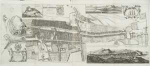
| Title: | The Plan of Edinburgh, exactly done… |
| Imprint: | [London] : John Bowles, [ca. 1814] |
| Pagination: | 1 map ; 44 x 107 cm., on sheet 49 x 110 cm. |
| Shelfmark: | EMS.b.3.22 |
| Zoom Into Map: | Click on the map to view in greater detail. |
| Notes: | Originally engraved ca. 1710, from a survey of Edinburgh by James Gordon of Rothiemay in 1647. |