Bartholomew's "Half Inch to the Mile Maps" of Scotland, 1899-1905
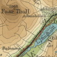
Bartholomew half-inch Scotland graphic

These clear and attractive maps at the half-inch to the mile scale (1:126,720), were popular with cyclists and tourists, and became Bartholomew's flagship series. The half-inch maps were distinctive for using different layers of colour to represent landscape relief, with a subtle and innovative gradation of colour bands used to show land at different heights. The 'New Series' maps shown on this page were developed in the 1890s out of Bartholomew's earlier Reduced Ordnance Maps of Scotland, 1875-1891.

We hold two sets of this series, the first from our Bartholomew Archive, and the second from our Newman collection.

This initial set of sheets is from our Bartholomew Archive and are held as flat sheets:

View sheets:
Sheet Number and Name    Date of Printing   
Sheet 1 - Wigtown Printed 1901
Sheet 2 - Solway District Printed 1903
Sheet 3 - Arran & Lower Clyde Printed 1904
Sheet 4 - Ayr & Clydesdale Printed 1900
Sheet 5 - Moffat, Hawick & Border Printed 1903
Sheet 6 - Islay, Jura, Colonsay Printed 1901
Sheet 7 - Glasgow & Clyde Printed 1902
Sheet 8 - Edinburgh District Printed 1903
Sheet 9 - Berwick & Haddington Printed 1903
Sheet 10 - Mull Printed 1899
Sheet 11 - Oban & Loch Awe Printed 1903
Sheet 12 - Central Perthshire Printed 1903
Sheet 13 - Perth & Dundee Printed 1903
Sheet 14 - Mallaig Printed 1901
Sheet 15 - Fort-William District Printed 1904
Sheet 16 - Braemar and Blair Atholl Printed 1902
Sheet 17 - Aberdeen & Deeside Printed 1903
Sheet 18 - North & South Uist Printed 1904
Sheet 19 - Isle of Skye Printed 1904
Sheet 20 - Central Ross & Cromarty Printed 1902
Sheet 21 - Inverness & Spey Printed 1903
Sheet 22 - Peterhead & Banff Printed 1902
Sheet 23 - Outer Hebrides Printed 1902
Sheet 24 - Gair Loch & Loch Inver Printed 1900
Sheet 25 - Dornoch, Lairg Printed 1904
Sheet 26 - Cape Wrath & Tongue Printed 1902
Sheet 27 - Caithness District Printed 1902
Sheet 28 - Orkney Islands Printed 1900
Sheet 29 - Shetland Islands Printed 1905

This second set of sheets is at the shelfmark: Newman.349. These maps have been dissected and folded:

View sheets:
Sheet Number and Name    Date of Printing   
Sheet 1 - Wigtown Printed 1901
Sheet 2 - Solway District Printed 1903
Sheet 3 - Arran & Lower Clyde Printed 1904
Sheet 4 - Ayr & Clydesdale Printed 1900
Sheet 5 - Moffat, Hawick & Border Printed 1903
Sheet 6 - Islay, Jura, Colonsay Printed 1901
Sheet 7 - Glasgow & Clyde Printed 1902
Sheet 8 - Edinburgh District Printed 1903
Sheet 9 - Berwick & Haddington Printed 1903
Sheet 10 - Mull Printed 1899
Sheet 11 - Oban & Loch Awe Printed 1903
Sheet 12 - Central Perthshire Printed 1903
Sheet 13 - Perth & Dundee Printed 1903
Sheet 14 - Mallaig Printed 1901
Sheet 15 - Fort-William District Printed 1904
Sheet 16 - Braemar and Blair Atholl Printed 1902
Sheet 17 - Aberdeen & Deeside Printed 1903
Sheet 18 - North & South Uist Printed 1904
Sheet 19 - Isle of Skye Printed 1904
Sheet 20 - Central Ross & Cromarty Printed 1902
Sheet 21 - Inverness & Spey Printed 1903
Sheet 22 - Peterhead & Banff Printed 1902
Sheet 23 - Outer Hebrides Printed 1902
Sheet 24 - Gair Loch & Loch Inver Printed 1900
Sheet 25 - Dornoch, Lairg Printed 1904
Sheet 26 - Cape Wrath & Tongue Printed 1902
Sheet 27 - Caithness District Printed 1902
Sheet 28 - Orkney Islands Printed 1900
Sheet 29 - Shetland Islands Printed 1905
 

Copyright           Enquiries & Copies           Help