Estate Maps, 1750s-1900s

| Name: | Newall, Walter, 1780-1863 |
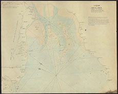
| Title: | Chart of the Solway Firth… [copied from the Thomas Winter Chart of 1742 ] |
| Imprint: | n.d. [c.1810-c.1850] |
| Pagination: | 1 manuscript map: col.; 47 x 59 cm. |
| Shelfmark: | GGD131/F5/10 |
| Notes: | Courtesy of the Ewart Library through the Dumfries Archival Mapping Project. |
| Zoom Into Map: | Click on the map to view in greater detail. |