Estate Maps, 1750s-1900s

| Name: | McCartney, William (fl. ca 1766-87) |
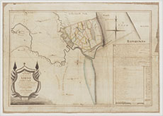
| Title: | Plan of the Lands of Airds of Kirkconnell, Surveyed and drawn with an express reference to the Cause depending between William Copland of Colliston & James Maxwell of Kirkconnell |
| Imprint: | 18 Feb 1782 |
| Pagination: | 1 manuscript map : col. |
| Shelfmark: | RHP92609(Rev) |
| Notes: | Courtesy of the Dumfries Archival Mapping Project - view futher details. View georeferenced map. |
| Zoom Into Map: | Click on the map to view in greater detail. |