- Jump to: Introduction | Poems |
- Scottish Place |
- Coverage |
- How to use this website |
- Selected further reading
Introduction
This website is dedicated to how places were presented, imagined, and described, in the poetry of premodern Scotland (medieval and early modern periods, c. 1400-1700). It is a collaboration between the National Library of Scotland and the University of Bristol, and the result of a British Academy Midcareer Fellowship on 'Place and Poetry in Premodern Scotland' held by Sebastiaan Verweij in 2023/24.
We hope to finalise this website by the summer of 2024.
Poems
- Henry Adamson, 'The Muses Threnodie...' 1638
- Poems to Scottish burghs: from Arthur Johnston, Encomia Urbium (1642) and John Johnston, Urbes Britanniae (1610)
- William Lithgow, 'The Pilgrime Entring into the Mouth of Clyde', 1618
- Francis Sempill, The Banishment of Poverty, c. 1680
Scottish Place
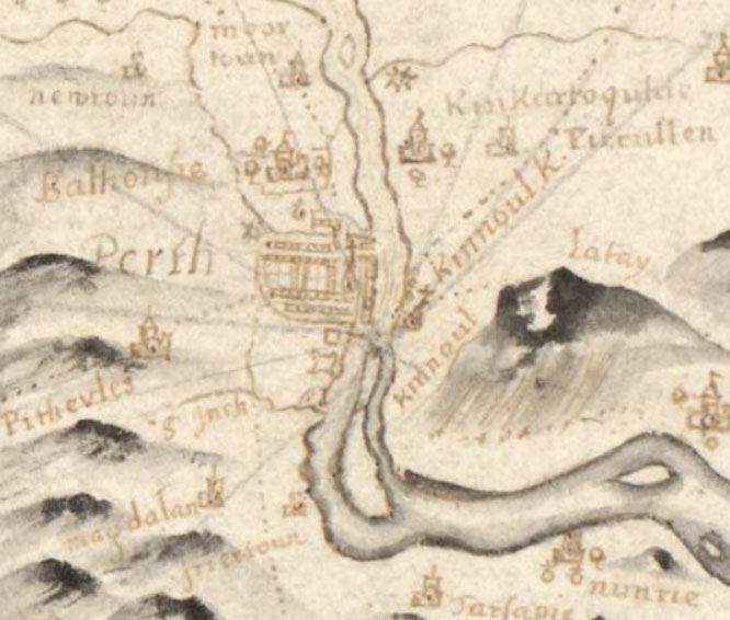
For the purpose of this website, a place can be many things: a town, burgh, building, or built object; a natural landmark, landscape feature, mountain, or river; and yet more diffuse places such as a country, a coast line, or a body of water. Scottish premodern poems are of course full of many more different types of places, not least imagined places, mythical places, disappeared places, and more. This website concentrates on places that can be located on a map of Scotland. The poems here featured illustrate how Scottish poets (and some visitors) viewed and experienced such Scottish places. The aim of this website is also to draw attention to a way of writing Scottish place that predates the Romantic representations which have so powerfully shaped modern cultural stereotypes of Scotland. Rather, from the earliest days of Scottish poetry, poets engaged profoundly with their geography, landscape, and environment, in ways that can tell us much about the lived experience of place. During the premodern period, Scots sought to represent their places in a variety of media. The sixteenth century saw the advent of mapping, and of chorography (description of regions, typically in words rather than in maps). Historians increasingly described the land as well as its people and their deeds. The earliest formal landscape paintings of Scotland were produced in the 1630s by a visitor, Alexander Keirincx, and a first wide-ranging set of engravings of towns, castles, and religious buildings, was produced by another visitor, John Slezer, in 1693. Such visual records form the backdrop to this website -- but it is the poetry that tells another more varied story about premodern Scottish places.
Coverage
The poems featured on this website are selected because of their density of interesting places, to provide some coverage of different genres, and to illustrate the many ways in which poets imagined a place. The featured poems are (to date) in two of the three major literary languages of Scotland: Scots (and English), and Latin (with translations). We hope at a later date to extend this website with poetry in Scottish Gaelic, to more fully represent Scotland's multilingual literary history of this period; and to represent some of the distinct kinds of place writing found in the Gaelic tradition. We welcome future collaborations and would like to hear from you about interesting poems that might feature on this website. Please contact Sebastiaan Verweij at s.verweij@bristol.ac.uk.
How to use this website
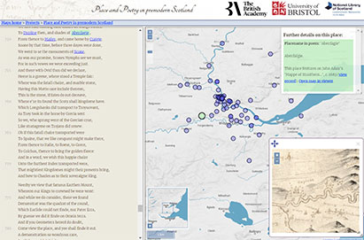
For each poem or series of poems, we present a text on the left hand side, and an interactive map on the right. Users can start from the poem, or from the map. Each poem is provided with a brief introduction. Each place mentioned in the poems (insofar possible) has been geolocated onto the modern map. An information panel on each place often provides links to a variety of historical maps from the holdings of the National Library of Scotland; or occasionally, to resources beyond the NLS websites. For each map, we provide two types of link. 'Open map in viewer' opens an additional map panel in overlay. 'View record' takes the user to the NLS catalogue entry for the map in question, for further information about the map and its maker(s) by way of context for the place described.
Selected further reading
A Vision of Britain through Time. Web resource from 1801 to the present day also covering Scotland and Scottish texts, featuring many Scottish places.
Cunningham, Ian C., ed., The Nation Survey’d: Timothy Pont’s Maps of Scotland (Edinburgh, 2001)
Fleet, Christopher, Margaret Wilkes, and Charles W. J. Withers, Scotland: Mapping the Nation (Edinburgh, 2011)
Mapping the Scottish Reformation. Web resource, ‘a digital prosopography of the Scottish clergy between 1560 and 1689’.
Mason, Roger A., 'From Buchanan to Blaeu: The Politics of Scottish Chorography, 1582-1654', in George Buchanan: Political Thought in Early Modern Britain and Europe, ed. by Roger A. Mason and Caroline Erskine (London, 2016), 13–47
Moir, D.G., The Early Maps of Scotland to 1850 (Edinburgh, 1973)
Verweij, Sebastiaan, 'Place, Poetry, and Politics: The Seventeenth- and Eighteenth-Century Reception of Alexander Montgomerie’s The Cherrie and the Slae', Scottish Literary Review, 15 (2023), 25–51
Watson, Fiona, A History of Scotland’s Landscapes (Edinburgh, 2018)
Withers, Charles W. J., Geography, Science and National Identity: Scotland since 1520 (Cambridge, 2001)
- Jump to: Introduction | Poems |
- Scottish Place |
- Coverage |
- How to use this website |
- Selected further reading


