Pont maps | Pont texts | biographies | history | subjects | further reading
Pont Maps of Scotland, ca. 1583-1614 - Pont texts
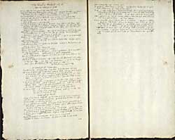
The Strath of Monteeth and all upon the northsyd of Gudy, The north [sic] syd of Teith River, North syd of Teeth
Pagination: 156v-157r
Transcription of text:
The Strath of Monteeth and all upon the northsyd of Gudy
Upon the south therof most part is moss except litle ward
Imprimis the kirk of the Poirt of Inch-mahume, half a myl thence Kurroch, 1 myl thence Rednock with a burn cuming doun from Achatreig. then is the Creig of the Poirt
Item Loch Rowiskich with an yl in it, the loch is smal, onlie of a quarter myl.
It is 2 myl north from thence to Kalender whiche standeth on the south syd of Teth.
The burn Rowiskich fals from thir loch, the burn of Rednoch meets with thir burn or they fal in Gudy.
A myl be east Rednoch the mill of Konisky.
The laird of Rowiskich cald Sir Murdo Menteeth being killed be his servant besyd Dumblane, his lands went in division among thrie daughters who wer maried to the Earl of Lennax and the Lairds of Marchiston and Glen-Eigise, whose heyrs do to thir possess them devyded be ridges.
Blairchoil 1 myl be east Rednoch, half a myl be east that upon the Moss is Kaillymuck, then Rowiskich burn, and a myl be east upon the moss the Torr of Rowiskich, and theis thrie ar upon the moss marching with Gudy river
Be west the last is Glen-owgader, a myl above it Suyack. a myl be east is Achanasilt with a burn, the chappell, a chappel with orchards.
Half a myl thence a burn and a myl more eastward Sessin-tilly and half a myle from that is Buchable
Item Mackorenstoun is a myl be east Buchable, hard by is Murdachstoun sumwhat be west the former.
Nixt is Balintoun. Item Burnbank
Betuix Balintoun and Burnbank is Coldoch
Be north Burnbank half a myl is Balnagrew, hard by is Spitteltoun, and be north half a myl is Makeonstoun. Nordwest [?] from it a myl is Gartynkevyr
Item be east Burnbank is Tuggairt with a burn and a mill cuming from the loch of Watstoun.
Hard by is the kirk of Kincairn, half a myl east therfra Boirland and hard by is Torr upon Teith. from Torr 1 myl Lochtertyrr. 2 myl be east Druyip-foord. Item Blackdubb the old way whair the water ran.
So end thois on the south of Teiyth
The north [sic] syd of Teith River
Loch Bennachar, Kilmahug kirk, Leny kirk, Kalendar kirk and tour.
The water of Garve-viisk meets with the water of Teith above the kirk and place of Kalender half a myl. Kalendar is on the southsyd of Teeth. A myle from Kalender, stil upon the southsyd of Teeth is Grinok with the burn of Alt-Whurr, a myl thence N. Torry with a smal burn. Item Ovir Torry be south the former half a myl.
2 myl thence Daldauran, 1 myl thence Lainrick a fair castel of Glen-eigis hard upon Teeth. hard by is Broich a myl east is Watstoun, half a myl from Teeth. half a myl thenfra Deanstoun, with a wood and crouves for salmond fishing, a quarter myl thence the brig of Doun.
Be east the bridge a myl is Derrara with a burn and Cowisky hard by
This marcheth with the strath of Menteeth agayn wher we left befor. Thes upon the south syd of Teth.
North syd of Teeth
Leny with the burn of Coryfoald, the old Castel of Leny at the mouth of the said burn. Item Craigmoir of Kalendar, the kirk of Kalendar, 2 myl Innerchailty, thir burn is 4 myl long.
Item the uppermost upon Kailty, betuix that and the brae of Glen Airtnay is Binchroin. Item Slew-Bakan [?] with Bakan. Item Glen-Shyro be west, and Stroin-Edernaig 2 myl from the former.
Item upon the head of Kailty is Drum Buy, hard by is Orb. a quarter myl be east the head of Kailty is Wester Brockland with Easter Brockland, with a very hollow glen.
A myl therfra upon the westsyd of Kailty is Achalawich, and upon the east syd Achaleshy fornent Achalawich
Fornent Innerkailty is Cammez-moir and be east it a small wood Calchaven is betuix the twa Cammez and Gairt with a wood be west Kailty.
Nixt Cammez-beg 1 myl Cammez moir
A myl thence Aldan-Leacah 4 myl long. twa myl thence Kailly-chat with a great burn falling out of the mouth of Owa-moir.
A myl be north Kailly-chat is Heglis-Stinchenach, and 2 myle be east that Annets, standing upon the head of the burn of Kailly-chat. Tua myl furdir is Kaillintuy, whilk is a myl from the syd of Teeth. A myl furdir nordeast is Cammez Wallace.
Half a myl thence the burn of Cammez falling in Teth hard at the kirk of Kilmadok, heir is the Park of Doun. nixt Down Newtoun
Fornent Innerallon upon the mouth of Allon is Cornetoun, a myl thence is Etthra, a myl thence Coks-burne. Item ther is Aldwhary a burn, it is 5 myl long cumming down from the Green forret be east Sherif-moor, the uppermost seat on thir burn is cald Glenty, a myl upon the south syd therof is the Park. Item Pendryich, be west it half a myl the standing stanes in Sherif-moor, a myl be west Caldhems. 2 myl thence Kippen-Ros upon the west cheek of Ald whary upon a myl. Drumadoul from Pendrich half myl fornent Kippen-ross upon Ald-whary.


