Pont maps | Pont texts | biographies | history | subjects | further reading
Pont Maps of Scotland, ca. 1583-1614 - Symbols and Abbreviations
Symbols frequently used by Pont are shown below. The use of standardised
symbols was in its infancy in Pont's day, and he is not consistent in his
use of symbols. It should also be noted that some symbols on the maps were
added by others particularly Robert Gordon after Pont's death.
See also:


 Rivers may be shown
by single or double lines. Sometimes, the direction of flow is indicated
by an arrow. Lochs may be shown by single lines, sometimes emphasised
by shading.
Rivers may be shown
by single or double lines. Sometimes, the direction of flow is indicated
by an arrow. Lochs may be shown by single lines, sometimes emphasised
by shading.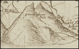


 Significant individual
buildings are usually shown by a tiny sketch, often with architectural
details and surrounding enclosures or gardens. According to a key
which Pont himself provides on his manuscript map no.36, the number
of dots on the representation of a building may indicate the number
of storeys it has.
Significant individual
buildings are usually shown by a tiny sketch, often with architectural
details and surrounding enclosures or gardens. According to a key
which Pont himself provides on his manuscript map no.36, the number
of dots on the representation of a building may indicate the number
of storeys it has.  Many towns are shown
by a sketch of the town. This example shows Perth.
Many towns are shown
by a sketch of the town. This example shows Perth.  These may appear as
a cross within a burghs
These may appear as
a cross within a burghs 


 These are often shown
by a Maltese cross and also by the abbreviation 'K:'
These are often shown
by a Maltese cross and also by the abbreviation 'K:'  Chapels are shown less
frequently than churches, and do not have a specific symbol. They
are generally indicated by chapel or chapell.
Chapels are shown less
frequently than churches, and do not have a specific symbol. They
are generally indicated by chapel or chapell. These are often shown
by a sketch of the building.
These are often shown
by a sketch of the building.  In general, Pont does
not show roads. An exception is the 'Causway' near Aberdeen.
In general, Pont does
not show roads. An exception is the 'Causway' near Aberdeen. 
 Concentric circles are
used by Pont to depict mines.
Concentric circles are
used by Pont to depict mines. Pont indicates standing
stones with a small drawing of a monolith, sometimes accompanied
by the word 'stone'.
Pont indicates standing
stones with a small drawing of a monolith, sometimes accompanied
by the word 'stone'. 


Abbreviations
The following are some of Pont's most frequently-used abbreviations:
- B = Baron, Bridge
- E = East, Easter
- G = Gudeman
- K = Kirk
- L = Laird, Loch
- La = Laird
- M = Master
- N = North, Nether
- O = Over
- R = River
- W = West, Wester
- : = abbreviation, eg. La: §: = Laird of...

- ~ = letter(s) omitted - usually an 'm' or 'n' at the end of a word.

- A line or dotted line may link a name with a particular location or symbol

Key
Pont seems to have been familiar with the concept of a key to symbols or 'characters'. On one of his maps, Pont map <36>, he provides his own key to some of his symbols. It is reproduced below, accompanied by a transcription of the Latin text and an English translation provided by Dr Jeffrey C. Stone and Ian C. Cunningham. 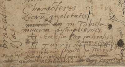
-
Characteres
Characters
Locorum qualitates
the kinds of places
invincem dn in Tabula
in the map
invicem distinguentes
distinguished by turn
Ecclesia Parochialis
Parish church
aedium effigies
representation of building
et formam
and its shape
Turris
Tower
punctorum series in Turribus
series of dots in towers
et aliis aedificiorum figuris
and other drawings of buildings
gradus altitudinis domorum [demonstrans?]
showing stages of height of the houses