Pont maps | Pont texts | biographies | history | subjects | further reading
The Architecture of Scotland
by Charles McKean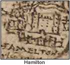
Timothy Pont's maps provide a quite remarkable picture of Scottish buildings at the end of the sixteenth century.
Although drawings of buildings were not unusual on European or English maps at that time, what distinguishes Pont's maps is the frequency with which they occur, their apparent verisimilitude, and their depiction of the lesser buildings of the countryside, where other maps illustrate only houses of the greatest magnates (if at all), and then only by notation. Pont's drawings of the larger houses appear to be elevations of their entrance façade to a minute scale: Craignethan to a scale of approximately 1:4000 and Hamilton Palace to a scale of 1:3600.
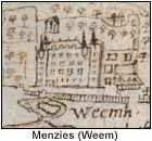
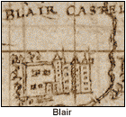
In the key to his drawings on the back of the West Lothian and Linlithgow map (Pont <36>), country seats (which Pont calls 'towers'), are shown as towers - tall freestanding rectangles which would vary in size to reflect the building's scale. As he puts it in the accompanying Latin text 'Tower/series of dots in towers/and other drawings of buildings/showing stages of height of the houses.' However, most of Pont's drawings deviate from the key: very few country seats are shown as freestanding, for around their feet he shows other, lower buildings, providing an indication of 'yards'. It must have required enormous and painful effort to execute drawings to such a tiny scale whilst managing to retain some recognisability (never mind finding adequate space at the right location on the manuscript), so each painstaking variation from the notation shown in the key may have been intended to convey information about the buildings' size and status. The most significant deviation from the key is the way Pont's drawings elaborate the flat-topped 'tower' symbol to indicate the richer detail: silhouette - in Foulis, Perthshire; dormer windows - Castle Menzies, Perthshire; occasional crenellations - Avondale (or Strathaven), Lanarkshire; turrets - Blair, Perthshire; stairtowers - Pardovan, West Lothian; cupolas - Glamis, Angus; chimneys - Hamilton Palace, Lanarkshire.
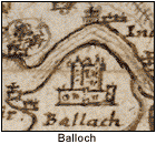
How credible are these drawings? Hamilton Palace, on the only dated map, Glasgow and the county of Lanark, 1596 (Pont 34), is portrayed as a main house flanked by two, taller flat-topped towers, with its entrance in the centre beneath a façade capped by tall chimneys. Isaac Miller's somewhat naïve elevation of the palace eighty years later shows virtually the same. Pont's depiction of Balloch (later Taymouth), the seat of Sir Duncan Campbell of Glenorchy that his father had built c.1559, can be substantiated by the drawing in William Adam's Vitruvius Scoticus. So it is likely that these tiny sketches do indeed represent what Pont saw. Where he indicates a location, with or without a building, there was probably a settlement or structure in the late sixteenth century.
The drawings seem to indicate four different scales of higher rank country seats (with a reasonable stab at conveying their appearance) with a standardised notation for lesser rural buildings like mills, windmills, tidemills, farms, fermtouns, cottowns and kilns. The smaller houses all have chimneys, implying that they were more than just peasant hovels - possibly those yeomen's houses to which Pont referred in his description of Cunninghame: 'the duellings of the zeomanrie verry thick poudred over the face of this countrey, all for the most part weill and commodiously planted and granished'. In the earlier manuscripts, a house of the first rank is depicted as never less than four storeys in height, enjoying a full heraldic complement on the skyline surrounded by lesser buildings and usually with an outline of park enclosure. Second rank homes are of similar scale without the heraldic superstructure.
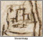
The drawing of Invermay, for example, implies a large, old-fashioned tower with some surrounding yards, well suited to Lord Innermeath who, as the spy reported to Lord Burleigh, was 'of no greate power, of indifferent lyvinge, no greate vundertakers'. It was nothing to compare with the flamboyance of nearby Kincardine, principal seat of the Earls of Montrose. Lesser houses were shown as smaller scale versions of Invermay. The implication of a visually expressed hierarchy of Scots Renaissance houses is reinforced by a study of almost any heavily populated district on the Pont maps. The House of Kelly, Angus, is depicted as having two towers, a linking block, yards and a park, by far the largest of the houses of the district. Yet nearby houses like Colliston, Guynd, Cuthlie and Cononsyth were themselves far from insubstantial: only Kelly, however, had the tower.
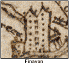
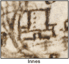
Pont's drawings can help retrieve pieces of history. The Earls of Crawford, for example, so prominent in the sixteenth century, must have occupied a more imposing seat than the surviving ruin of a small four-storeyed tower at Finavon on the banks of the South Esk, thought to have been built in the early seventeenth century, or the pleasant villa of Balcarres in Fife. Pont's Finaven is a twin gabled, seven storeyed giant well worthy of that tempestuous family - the tallest building that Pont drew. What survives now was but an appendage. It was another Pont drawing that prompted a review of the architectural history of Innes House, by Elgin, which has fundamentally changed our perception of its history; and his drawing of nearby Coxton Tower shows it to be at least fifty-three years older than the 1640s date usually attributed to it.
(Historians have again been misled by yet another deceiving datestone.) So if there were indeed buildings approximately where Pont placed them in the late sixteenth century, approximately to the scale and heraldic, social or industrial importance that he indicates, Scotland was well provided with country seats, many of considerable splendour.
This article is derived from Charles McKean's The Scottish Château:
the country house of Renaissance Scotland (Stroud, 2001). For a
fuller discussion of Pont's depiction of buildings, see the chapter
'Timothy Pont's Building Drawings' by Charles McKean in The Nation
Survey'd, edited by Ian C. Cunningham.
