Military Maps of Scotland (18th century)
Your search returned 5 records.
Ordered chronologically (undated items first).
| Title: | This Plan containing Lochness Lochoyoch, Lochlochey, & all the Rivers and Strips of water that Runs in & set out from the same, from the East Sea before Inverness to the West Sea at Inverlochey before Fort William, together with all Roads & Remarkable pla | |
| Name: | Avery, Joseph | |
| Survey: | [ca.1727] | |
| Shelfmark: | MS.1648 Z.03/21 | |
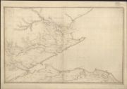
| Title: | [Plan of the Murray Firth and Cromarty Firth, with parts of the Shires of Inverness, Sutherland, Ross, Nairn, and Elgin. Showing roads] | |
| Name: | [Avery, Joseph Wade, George (Engineer)] | |
| Survey: | 1730 | |
| Shelfmark: | Acc.10497 Wade.58d | |
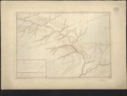
| Title: | A Plan of the Country where the New Intended Road is to be made from the Barrack at Ruthven in Badenoth to Invercall in Brae Marr… | |
| Name: | Avery, Joseph (Engineer) [Wade, George (Engineer)] | |
| Survey: | 1735 | |
| Shelfmark: | Acc.10497 Wade.58b | |
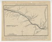
| Title: | General Wade's plan for a Glenfeshie road. | |
| Name: | Avery, Joseph / Mathieson, John | |
| Survey: | 1923 | |
| Shelfmark: | EMS.b.2.174(24) | |
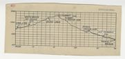
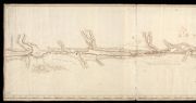
| Title: | [Profile of the proposed route of Wade's road from Linn of Dee via Geldie Lodge and Glen Feshie to Tromie Bridge] | |
| Name: | Avery, Joseph / Mathieson, John | |
| Survey: | 1923 | |
| Shelfmark: | EMS.b.2.174(24) | |