Military Maps of Scotland (18th century)
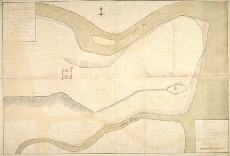
| Title: | A plan of the Barracks of Killiwhymen and of the Ground about it... |
| Name: | Debize, R. [Wade, George (Engineer)] |
| Description: | 1 manuscript map : col. ; 480 x 707 mm., on sheet 507 x 978 mm. |
| Original Survey: | 10 February 1724-5 |
| Date on Map: | 10 February 1724-5 |
| Placename: | Fort Augustus |
| Parish: | Boleskine and Abertarff |
| County: | Inverness-shire |
| Shelfmark: | Acc.10497 Wade.58g |
| Zoom Into Map: | Click on the map to view in greater detail. |
All images © National Library of Scotland