Military Maps of Scotland (18th century)
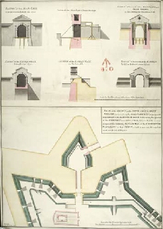
| Title: | Plan of the front on the Entrance to Fort William, representing the Main Gate Way as proposed to be rebuilt with the Wing Walls sustaining the ground of the Rampart on each side of the Entrance. And the manner proposed for forming the Earth Work of the R |
| Name: | Campbell, Dugal (Engineer) Field, John (Copyist) |
| Description: | 1 manuscript map ; 680 x 479 mm., on sheet, 712 x 502 mm. |
| Original Survey: | [1744] |
| Date on Map: | 1812 |
| Placename: | Fort William |
| Parish: | Kilmallie |
| County: | Inverness-shire |
| Shelfmark: | MS.1646 Z.02/27b |
| Zoom Into Map: | Click on the map to view in greater detail. |
All images © Crown Copyright and © National Library of Scotland