Military Maps of Scotland (18th century)
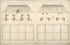
| Title: | [Plans of the Soldiers' Barracks, Fort William]; The front of ye Souldiers Barracks as it appears to the Rampart, Fort William, K; The Front of the Soldiers Barracks as it appears to the Parade, Fort William, K; A Plan of the Souldiers Barracks that is ne |
| Name: | Petit, Lewis (Engineer) |
| Description: | 1 manuscript map ; 454 x 720 mm., on sheet, 493 x 733 mm. |
| Original Survey: | 1712 |
| Date on Map: | 1712? |
| Placename: | Fort William |
| Parish: | Kilmallie |
| County: | Inverness-shire |
| Shelfmark: | MS.1646 Z.02/25b |
| Zoom Into Map: | Click on the map to view in greater detail. |
All images © Crown Copyright and © National Library of Scotland