Military Maps of Scotland (18th century)
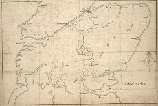
| Title: | [Map showing the intended military roads joining up Stirling with Fort Augustus, etc.] |
| Name: | [Wade, George (Engineer)] |
| Description: | 1 manuscript map : col. [coast] in blue ; 360 x 500 mm., on sheet, 360 x 522 mm. |
| Original Survey: | [ca. 1724-45?] |
| Date on Map: | [ca. 1724-45?] |
| Placename: | Stirling, Fort Augustus |
| Parish: | Stirling |
| County: | Stirlingshire, Perthshire, Inverness-shire |
| Shelfmark: | Acc.10497 Wade.58e |
| Zoom Into Map: | Click on the map to view in greater detail. |
All images © National Library of Scotland