Military Maps of Scotland (18th century)
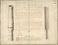
| Title: | Munsmeg, a Gun so called, at Edinburgh Castle; her Demensions, Requisite of Powder, Weight of Shott, greatest Range, Force etc., areas follow |
| Name: | Borthwick, Robert (Engineer) |
| Description: | 1 manuscript map ; 350 x 447 mm., on sheet, 367 x 469 mm. |
| Original Survey: | 1734 |
| Date on Map: | 1734 |
| Placename: | Edinburgh Castle |
| Parish: | Edinburgh |
| County: | Edinburghshire/Midlothian |
| Shelfmark: | MS.1645 Z.02/11 |
| Zoom Into Map: | Click on the map to view in greater detail. |
All images © Crown Copyright and © National Library of Scotland