Military Maps of Scotland (18th century)
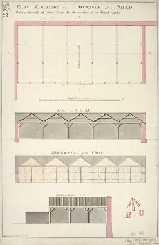
| Title: | Plan, Elevation and Sections of a Shed, Ordered to be built at Edinbo. Castle for the reception of 50 Bread Carts. [1746] [copy] |
| Name: | Campbell, Dugal (Engineer) Spencer, John (Copyist) |
| Description: | 1 manuscript map ; 467 x 306 mm., on sheet, 495 x 323 mm. |
| Original Survey: | 1746 |
| Date on Map: | 1795 |
| Placename: | Edinburgh Castle |
| Parish: | Edinburgh |
| County: | Edinburghshire/Midlothian |
| Shelfmark: | MS.1645 Z.02/06b |
| Zoom Into Map: | Click on the map to view in greater detail. |
All images © Crown Copyright and © National Library of Scotland