Military Maps of Scotland (18th century)
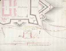
| Title: | [Plan of Fort George, Ardersier, showing] Present Road leadng Through the Gancion [and] Proposed Road to the Ferry |
| Name: | Frazer Andrew (Engineer) |
| Description: | 1 manuscript map ; 350 x 446 mm. |
| Original Survey: | [1787] |
| Date on Map: | [1787] |
| Placename: | Fort George (Ardersier) |
| Parish: | Ardersier |
| County: | Inverness-shire |
| Shelfmark: | MS.1650 Z.46/57d |
| Zoom Into Map: | Click on the map to view in greater detail. |
All images © Crown Copyright and © National Library of Scotland