Military Maps of Scotland (18th century)
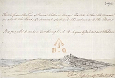
| Title: | Sketch from the Face of Prince William Henrys Bastion, to Shew the Manner in which the Bank at present obstructs the entrance to the bason [Fort George, Ardersier] |
| Name: | Shipley, Sir Charles (Engineer) |
| Description: | 1 manuscript map ; 221 x 324 mm. |
| Original Survey: | 1787 |
| Date on Map: | 1787 |
| Placename: | Fort George (Ardersier) |
| Parish: | Ardersier |
| County: | Inverness-shire |
| Shelfmark: | MS.1650 Z.46/57b |
| Zoom Into Map: | Click on the map to view in greater detail. |
All images © Crown Copyright and © National Library of Scotland