Military Maps of Scotland (18th century)
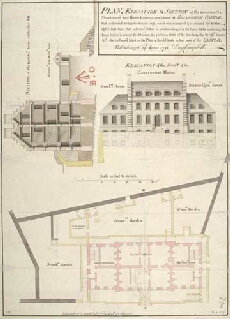
| Title: | Plan, Elevation & Section of the Governour's, Storekeeper's and Master Gunners new houses at Edinburgh Castle. [1742] |
| Name: | Campbell, Dugal (Engineer) |
| Description: | 1 manuscript map ; 631 x 457 mm., on sheet, 643 x 470 mm. |
| Original Survey: | 1742 |
| Date on Map: | 14 June 1742 |
| Placename: | Edinburgh Castle |
| Parish: | Edinburgh |
| County: | Edinburghshire/Midlothian |
| Shelfmark: | MS.1645 Z.02/05b |
| Zoom Into Map: | Click on the map to view in greater detail. |
All images © Crown Copyright and © National Library of Scotland