Military Maps of Scotland (18th century)
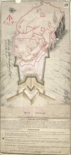
| Title: | A Plan of Edinburgh Castle |
| Name: | Edwards, Talbot (Engineer) |
| Description: | 1 manuscript map ; 572 x 259 mm., on sheet, 587 x 271 mm. |
| Original Survey: | 1709 |
| Date on Map: | 1709 |
| Placename: | Edinburgh Castle |
| Parish: | Edinburgh |
| County: | Edinburghshire/Midlothian |
| Shelfmark: | MS.1649 Z.03/58a |
| Zoom Into Map: | Click on the map to view in greater detail. |
All images © Crown Copyright and © National Library of Scotland