Military Maps of Scotland (18th century)
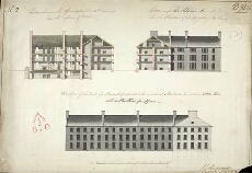
| Title: | Section through the Officers Apartments etc. shewing also the Mess-room & Kitchens; Section across the Soldiers Barrack, shewing also the Elevation of the projecting Building; Elevation of the Front of a Barrack, proposed to be erected at Aberdeen, to con |
| Name: | Rudyard, Henry (Engineer) |
| Description: | 1 manuscript map ; 352 x 510 mm., on sheet, 367 x 527 mm. |
| Original Survey: | 1792 |
| Date on Map: | 1792 |
| Placename: | Cumberland Fort, Aberdeen |
| Parish: | Old Machar |
| County: | Aberdeenshire |
| Shelfmark: | MS.1649 Z.03/52b |
| Zoom Into Map: | Click on the map to view in greater detail. |
All images © Crown Copyright and © National Library of Scotland