Military Maps of Scotland (18th century)
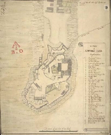
| Title: | A Plan of Edinburgh Castle [1737] [copy] |
| Name: | Romer, John Lambertus (Engineer) |
| Description: | 1 manuscript map ; 442 x 364 mm., on sheet, 457 x 368 mm. |
| Original Survey: | pre-1742 |
| Date on Map: | 1742 |
| Placename: | Edinburgh Castle |
| Parish: | Edinburgh |
| County: | Edinburghshire/Midlothian |
| Shelfmark: | MS.1645 Z.02/04d |
| Zoom Into Map: | Click on the map to view in greater detail. |
All images © Crown Copyright and © National Library of Scotland