Military Maps of Scotland (18th century)
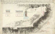
| Title: | Plan of part of the North-end of Dunbarton Castle; with two different Designs, and proposed situation for a Barrack to accommodate a Company of Foot; also a Project for rebuilding the Wall near the One Gun Battery which from its present ruinous state, ver |
| Name: | Rudyard, Henry (Engineer) |
| Description: | 1 manuscript map ; 470 x 752 mm. |
| Original Survey: | [1788] |
| Date on Map: | [1788] |
| Placename: | Dumbarton Castle |
| Parish: | Dumbarton |
| County: | Dumbartonshire |
| Shelfmark: | MS.1649 Z.03/49 |
| Zoom Into Map: | Click on the map to view in greater detail. |
All images © Crown Copyright and © National Library of Scotland