Military Maps of Scotland (18th century)
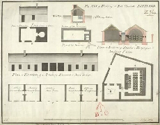
| Title: | Plan of Buildings at Fort Charlotte Shetland |
| Name: | Frazer, Andrew (Engineer) |
| Description: | 1 manuscript map ; 348 x 448 mm., on sheet, 366 x 486 mm. |
| Original Survey: | 1786 |
| Date on Map: | 1786 |
| Placename: | Fort Charlotte |
| Parish: | Lerwick |
| County: | Shetland |
| Shelfmark: | MS.1649 Z.03/44a |
| Zoom Into Map: | Click on the map to view in greater detail. |
All images © Crown Copyright and © National Library of Scotland