Military Maps of Scotland (18th century)
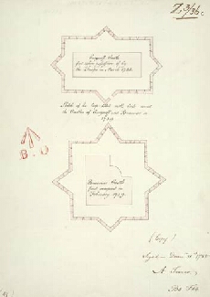
| Title: | Sketch of the loop-holed walls built round the Castles of Cargarff and Braemar in 1749 [copy] |
| Name: | Frazer, Andrew (Engineer) |
| Description: | 1 manuscript map ; 387 x 276 mm. |
| Original Survey: | 1785 |
| Date on Map: | 1785 |
| Placename: | Corgarff Castle |
| Parish: | Strathdon |
| County: | Aberdeenshire |
| Shelfmark: | MS.1649 Z.03/36c |
| Zoom Into Map: | Click on the map to view in greater detail. |
All images © Crown Copyright and © National Library of Scotland