Military Maps of Scotland (18th century)
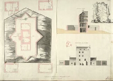
| Title: | Plans, Section & Elevation of the Barrack at Cargarff |
| Name: | Skinner, William (Engineer) Tarrant, Charles (Draughtsman) |
| Description: | 1 manuscript map ; 511 x 713 mm., on sheet, 527 x 717 mm. |
| Original Survey: | [1750] |
| Date on Map: | [1750] |
| Placename: | Corgarff Castle |
| Parish: | Strathdon |
| County: | Aberdeenshire |
| Shelfmark: | MS.1649 Z.03/35c |
| Zoom Into Map: | Click on the map to view in greater detail. |
All images © Crown Copyright and © National Library of Scotland