Military Maps of Scotland (18th century)
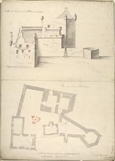
| Title: | Plann of the Castle of Island Dounan; Profile of the Front of the Castle of Island Dounan markt ABCD |
| Name: | Petit, Lewis (Engineer) |
| Description: | 1 manuscript map ; 722 x 514 mm., on sheet, 738 x 529 mm. |
| Original Survey: | [1714] |
| Date on Map: | [1714] |
| Placename: | Eilean Donan |
| Parish: | Kintail |
| County: | Ross & Cromartyshire |
| Shelfmark: | MS.1648 Z.03/26a |
| Zoom Into Map: | Click on the map to view in greater detail. |
All images © Crown Copyright and © National Library of Scotland