Military Maps of Scotland (18th century)
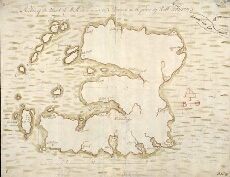
| Title: | A Plan of the Island of Mull with the adjacent Islands Drawen on the place |
| Name: | Johnson, Robert (Overseer) |
| Description: | 1 manuscript map ; 368 x 469 mm. |
| Original Survey: | [1741] |
| Date on Map: | [1741] |
| Placename: | Mull |
| County: | Argyllshire |
| Shelfmark: | MS.1648 Z.03/23a |
| Zoom Into Map: | Click on the map to view in greater detail. |
All images © Crown Copyright and © National Library of Scotland