Military Maps of Scotland (18th century)
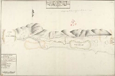
| Title: | A Draught of Innersnait, in the Highlands of North Brittain, nere the Head of Loch Lomend with part of the country adjacent [copy] |
| Name: | Dumaresq, John & Bastide, John Henri (Engineer) Bastide, John Henri (Draughtsman) |
| Description: | 1 manuscript map ; 447 x 677 mm., on sheet, 464 x 695 mm. |
| Original Survey: | 1742 |
| Date on Map: | 1742 |
| Placename: | Inversnaid |
| Parish: | Buchanan |
| County: | Stirlingshire |
| Shelfmark: | MS.1648 Z.03/15c |
| Zoom Into Map: | Click on the map to view in greater detail. |
All images © Crown Copyright and © National Library of Scotland