Military Maps of Scotland (18th century)
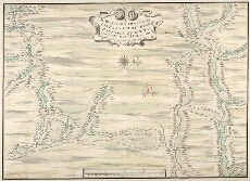
| Title: | A Map of the Roads between Innersnaid Ruthvan of Badenock, Kiliwhiman and Fort William, in the Highlands of North Brittain [1718] 1741[copy] |
| Name: | Dumaresq, John & Bastide, John Henri (Engineer) Bastide, John Henri (Draughtsman) Coombs, Richard (Copyist) |
| Description: | 1 manuscript map ; 453 x 631 mm., on sheet, 518 x 694 mm. |
| Original Survey: | 1741 |
| Date on Map: | 1741 |
| Placename: | Highlands (Roads) |
| County: | Stirlingshire, Perthshire, Argyllshire |
| Shelfmark: | MS.1648 Z.03/14a |
| Zoom Into Map: | Click on the map to view in greater detail. |
All images © Crown Copyright and © National Library of Scotland