Military Maps of Scotland (18th century)
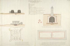
| Title: | Plan Section and Elevation of the barracks at Killiwhimen, with a particular plan and section of the cistern [1723] [copy] |
| Name: | Romer, John Lambertus (Engineer) |
| Description: | 1 manuscript map ; 480 x 716 mm., on sheet, 494 x 716 mm. |
| Original Survey: | 1766 |
| Date on Map: | 1766 |
| Placename: | Fort Augustus |
| Parish: | Boleskine and Abertarff |
| County: | Inverness-shire |
| Shelfmark: | MS.1647 Z.03/12b |
| Zoom Into Map: | Click on the map to view in greater detail. |
All images © Crown Copyright and © National Library of Scotland