Military Maps of Scotland (18th century)
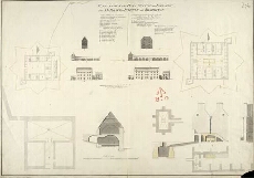
| Title: | Plan, Section and Elevation of the Barrack at Inveersnait and Kiliwhiman [with] Explanation; Powder Magasine at Edinbgh. Castle and Section of the Same at x; with a project of Arching the second Floor at y [1720] [copy] |
| Name: | Romer, John Lambertus (Engineer) Chamberlaine, Thomas (Draughtsman) |
| Description: | 1 manuscript map ; 495 x 713 mm., on sheet, 526 x 732 mm. |
| Original Survey: | 1798 |
| Date on Map: | 1798 |
| Placename: | Inversnaid |
| Parish: | Buchannan |
| County: | Inverness-shire, Stirlingshire |
| Shelfmark: | MS.1647 Z.03/11b |
| Zoom Into Map: | Click on the map to view in greater detail. |
All images © Crown Copyright and © National Library of Scotland