Military Maps of Scotland (18th century)
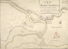
| Title: | A Plan of the Barrack at Kiliwhiman And of the Ground within the bounds of it betwixt the two Rivers & the letters AB.C |
| Name: | Dumaresq, John & Bastide, John Henri (Engineer) Bastide, John Henri (Draughtsman) |
| Description: | 1 manuscript map ; 311 x 435 mm., on sheet, 319 x 443 mm. |
| Original Survey: | 1718 |
| Date on Map: | 1718 |
| Placename: | Fort Augustus |
| Parish: | Boleskine and Abertarff |
| County: | Inverness-shire |
| Shelfmark: | MS.1647 Z.03/08a |
| Zoom Into Map: | Click on the map to view in greater detail. |
All images © Crown Copyright and © National Library of Scotland