Military Maps of Scotland (18th century)
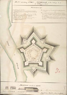
| Title: | Plan for building A Fort at Inverness on the Vestige of an old Fort demolished 1746 |
| Name: | Skinner, William (Engineer) Tarrant, Charles (Draughtsman) |
| Description: | 1 manuscript map ; 736 x 515 mm., on sheet, 748 x 535 mm. |
| Original Survey: | 1746 |
| Date on Map: | 1746 |
| Placename: | Fort George (Inverness) |
| Parish: | Inverness and Bona |
| County: | Inverness-shire |
| Shelfmark: | MS.1647 Z.02/82b |
| Zoom Into Map: | Click on the map to view in greater detail. |
All images © Crown Copyright and © National Library of Scotland