Military Maps of Scotland (18th century)
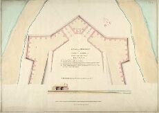
| Title: | A Plan of the West Front of Fort George, Commanding the Channel; Section thro the South Casmate marked FG |
| Name: | Skinner, William (Engineer) |
| Description: | 1 manuscript map ; 522 x 733 mm., on sheet, 545 x 756 mm. |
| Original Survey: | 1754 |
| Date on Map: | 1754 |
| Placename: | Fort George (Ardersier) |
| Parish: | Ardersier |
| County: | Inverness-shire |
| Shelfmark: | MS.1647 Z.02/53 |
| Zoom Into Map: | Click on the map to view in greater detail. |
All images © Crown Copyright and © National Library of Scotland